The Road Less Traveled
An exploration of a ghost town known as Dana, Massachusetts
April 28, 1938
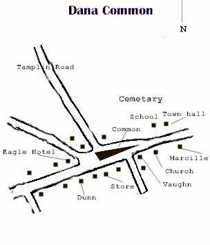
To all former Town Officers of the Towns of Enfield, Greenwich , Dana, and Prescott : By the terms of Chapter 321, Act 1927, as amended by the Chapter 240 of the Acts of Resolves of the Legislature of the year 1938 , you are hereby formally notified that the corporate existence of the aforesaid towns ceased at 12 o'clock midnight, April 27 th . In view of this fact, the town's officers are to carry on no municipal function on and after April 27 th and shall do only such acts as are necessary to effect the transfer of properties of the municipalities to the Metropolitan District Water Supply Commission and to effect the commitment of taxes to the town to which the respective territories are annexed. -Met. Dist. Water Supply Com. Well that was quite straightforward and to the point, was it not? That is a copy of the letter that the town officers of Dana , Massachusetts received to let them know their town now officially did not exist. Wiped off the State's list of cities, and soon to be wiped off the face of the earth. It was not the first time that the needs of the many grabbed the lands from the few who lived there. In the past it was the Nipmuk Indians who occupied the lands. The colonists stole the area known as Quaben from the Nimpmucks during King Phillip's war (1675-1676). Quaben was the Nipmuck name for the meeting of the many waters. Common sense will tell you this would be a great place to settle. A great place to build a reservoir, too. Dana was a quaint little town incorporated back in 1801. North Dana was the business district, having contributed largely to the farming industry and the palm-hat industry. Yes, palm-hats. They actually were largely popular in the mid 1800s, made with palm imported from South America . North Dana was sometimes called hat town by people in-the-know. They took their hats and exported them across the globe, even some back to South America where the palms came from in the first place. There was more than hats being made in Dana, however. Glazier Wheeler used to make counterfeit silver coins in North Dana until some raccoon hunters found out about his little operation. Boxes used to be made as well by the Swift River Box Company until about 1935. The Athol-Springfield rail line did run through North Dana which made exporting the products out of town an absolute breeze. Prior to making boxes, however, the factory was used to make soapstone sinks. The stone itself was quarried from the nearby town of Prescott , also dissolved in order to make room for the Quabbin reservoir. Now, however, nothing is made there except pictures. North Dana and parts of Dana itself are currently occupied by fish, stone, and water. Some of the old roads, old cellar holes, and even a few pieces of rusty metal still reside in the area. They await nothing except the slow passage of time and the occasional visitor trying to imagine what that time has done to the area. Here you can see a map of the Dana common, for your reference. You park at Gate 40 in order to access the ruins of the Dana community. Shortly after passing the gate itself you will see a small clearing and road to the right. This was the place where a local eccentric individual named Asa "Popcorn" Snow had his tomb. Asa was nicknamed "Popcorn" because he was a vegetarian whose favorite meal was, well, popcorn. Popcorn was placed in a metal casket with a window in it when he died back in 1872. The window was so the undertaker could visit him for 7 days after his death and make sure he really was dead. Talk about paranoid.... Perhaps his views on the matter weren't all without warrant, however. The MDC moved him and filled in his tomb when all the graves were relocated to make way for the reservoir. Rumor has it that he still haunts the area, greatly irked by the fact that his body and tomb were moved from what he wanted his final resting place to be. Note that I did not know this story before I visited, yet I certainly recall an uneasyness when I was there. There were no sounds at all. No birds, no wildlife, nothing at all. I was hunting for a geocache and the hair on the back of my neck kept standing up. That feeling that an animal was watching me, I'm sure you know it. Perhaps it wasn't an animal. Perhaps Popcorn was curious as to why this strange man was outside in the 30 degree 20 mph windy weather, apparently looking for something in an old abandoned stone wall. Sorry, Popcorn, I didn't mean to disturb you. Next time I go back I will say hi to you and let you know I am there. You continue down the main road for tad more than a mile when you come upon the town common, pictured in the map above. Right before the common you can see a short side-street that apparently was once the original road, but due to the "s" curve it was straightened out. I am told that there is a stone next to this road with the date "1899" chisled into it. Apparently this stone marks the place where Moses Marcille lived, as well as the location of a blacksmithy shop.
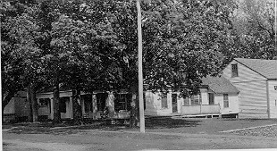
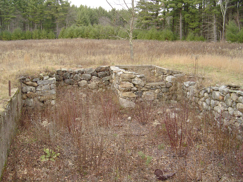
One of the first foundations that you will come across is that of either the Schoolhouse or the old Town Hall. I can't tell which one this was, but in either case this is one of the first cellar holes that you will come across. Then entire Quabbin watershed is littered with cellar holes, root cellars, old foundations and other historical artifacts. I have often wondered why they did not fill these in if they knew the water level would not rise this high. Odd. The old Town Hall in Dana was actually a converted church. I have read that visitors into the town were oft confused by this, as the real church was right across the road. I can imagine the workers in the Town Hall being so annoyed by parishioners coming in with the deer in the headlights look. "Where are the pews? What?"
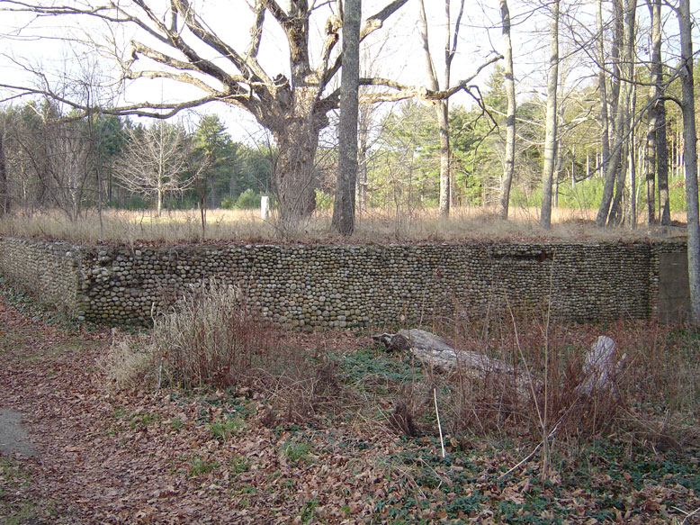
If one turns to face the south just about where the old picture was taken above (and a little to the southeast from my picture), you will come across an excellent example of old stone masonry. The Vaughn residence had a unique cobblestone foundation that still exists today. The house itself faced north, to look upon the town common itself. I took a few pictures of the foundation as it exists today. After digging a bit on the internet I also found some pictures of what it looked like when it stood in all its glory. If you take a peek in the lower-right hand of the old photo you will see the telltale cobblestone foundation. You can click the color photo for a full res image.
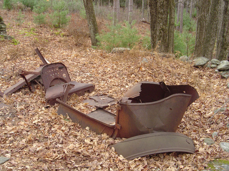
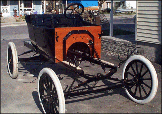
After visiting here for a bit, I proceeded down a road that went to the northwest. Not Tamplin road, but some other unamed road. When I got home and located a census map, I discovered that this long road, which now ends with "Graves landing", did not have that many residents living on the shapr bend in the road. I had taken a picture right after his hairpin turn in the road of a rusted old auto parked next to a foundation that I initially though could perhaps be a Model T. When I cross referenced this with the census map I found that a resident by the name of S. Skinner used to live here. Did I find his old auto? Did the state really forget to remove the car?? Now that I think about it, if you look at the photo closely you can see that this auto is actually on some perfectly flat ground with a stone retaining wall holding the area up. Perhaps this was a parking area or garage created by the home's owner. (click photo for larger image)
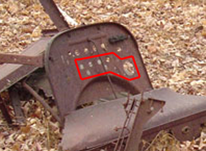
Upon further investigation I did turn up this picture of a 1913 Model T, restored, but what I am interested in is the pattern of holes in the dashboard. If we compare that picture with a blown up image of the wreck's dashboard, you can see the pattern of holes is almost the same. I highlighted the area I am talking about. Assuming that the dashboard above is actually turned facing away thus matching the direction of the modern photo, you can see a row of 4 holes, then two holes under that, making almost like eyes and nose of a smiley face.
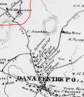
If you would like to see a map of the area that I found this car, check out this awsome series of pics I my little brain dreamt up. The first pic is the census map of Dana. Click each pic for a closeup. From the left, the first map is the census map. The hairpin turn and Skinner's house are in the upper left, highlighted in red. The map on the right is the census map merged with a Google Earth flyover imagery set to the same scale as the pic, and rotated. Apparently the census map was not to True North scale. It is amazing to see how most of the old roads line up just about perfectly! The Google earth imagery has the roads as white lines. Notice how the road running to the top of the photo goes right into the water. This was the road up to the factories of North Dana. Also note that on the census map there are numbers next to the roads, these are measurements in rods, not feet. 1 rod equals 16.5 feet. Click the photo to the right for full res imagery, it is easier to see! The area highlighted in red more or less matches the same highlighted area on the census map.
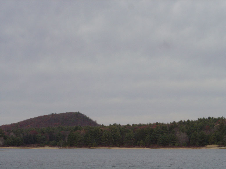
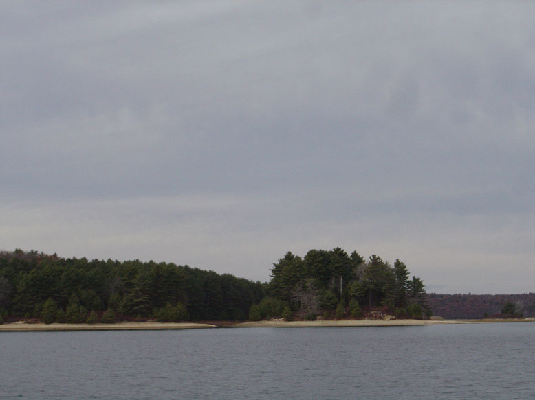
A bit farther north the road disappears into the water in an area known as Grave's Landing. "Grave" was the last name of one of the park rangers, not a reference to tombstones. This area gives you a nice view to the north, to what once was the North Dana area. Leveau Island is clearly visible, as is Rattlesnake Hill. Enjoy some of these pictures from the Landing. All are clickable for high red imagery.
Click to go on to page 2, more Common Pictures and the Starfighter Jet Crash site
|
|---|
 I actually was able to take a few pictures of the Vaughn stone foundtation, the school (or town hall, I'm not sure) foundation, and even an old car that I beleive to perhaps be a Model T. Who knows, after looking at the town census map perhaps I can even figure out who owned the car!
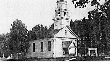 Here is what the Town Hall used to look like, looking north.