I started today's hike with the intent on finding a few geocaches in the area, "Keystone Arches" and "Whistler's Arches." I knew the area had historical signifigance as well, so I brought the camera along. This way you can come along with me as I describe the journey. Overall I spend about 3 or 4 hours there today, although the area could be done in much shorter time provided you don't stop to take in the sights. That is just not fun.
At the trailhead you will be presented with a nice information kiosk, complete with a map of the area and historical description of what went on here. There are no hand-out maps, but it is next to impossible to get lost. Nevertheless, if you have a GPS, mark your car. On the way in you can immediately tell that people do drive on this road. I am pretty sure the CSX railroad guys use this road to gain access to their rail lines for inspection. I mapped one of the roads, which doubles as the trail in parts, and it comes right out to the lines where there is a bridge.
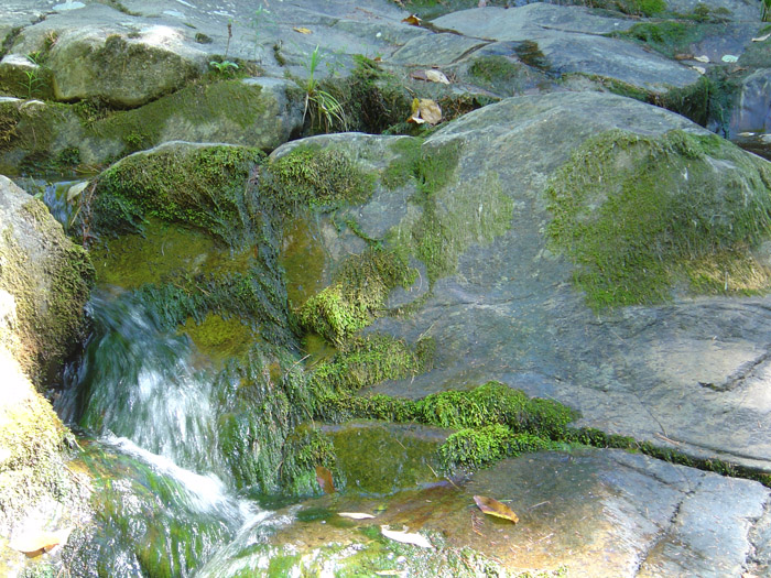
Right before you cross an iron-grate bridge you will hear some small waterfalls to your right. There is a geocache up there, so I headed to it and snapped some pics. A nice place for a rest on the way back from your trip.
Click on any one of the images to display a full resolution picture. The original fullsize images are available upon request. (The full resolution pictures you get by clicking on these thumnails are about 25% the size of the originals!) Once you click the image your browser may resize it to fit in your browser window, click it again and it may get even bigger!
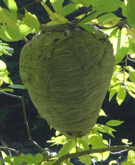
Continuing on the way I noticed I had some buzzing type visitors off to my left. They left me alone and let me take a picture of their awesomely big home. That must have been hard work for the little buggers. They have a great view of the river down below. The drop was too steep for me to risk taking a pic, sorry.
This portion of the trail is an old "highway" aka carraige/horse road that connected the Pittsfield area to the Springfield area. I beleive it was called the Pontoosuc turnpike if memory serves me correctly. I can't find any verification of that on the internet, although somewhere on one of the kiosks there is information about it.
 As you can see, trucks have made ruts in the road. Actually there were fresh tracks in the mud that must have been made within the past few days. I suspect the CSX guys were out making sure nothing washed away under the tracks after the heavy rain that we had on monday.
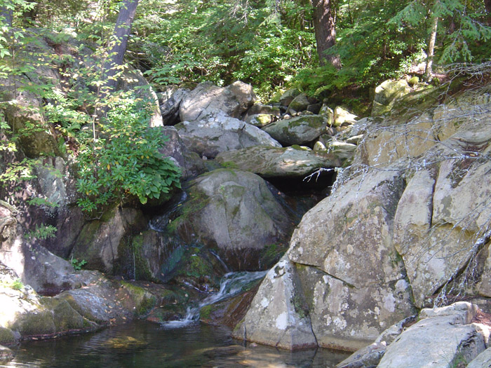
If you pay attention as you walk the trail that meanders along the river you will notice the occasional stone wall in the woods. The sound of the trickling water is never far away. In the spring, this section of the river can be class IV whitewater. I can imagine the ghosts of the past who made these stone walls just watching those people go down the river...thinking to themselves what a strange folk we have become.
A little farther up the way and still only about 20 minutes into the hike you come across a more modern bridge then the arches you will see. It's just a short one minute 'side trail' off the main road, you can't miss it. 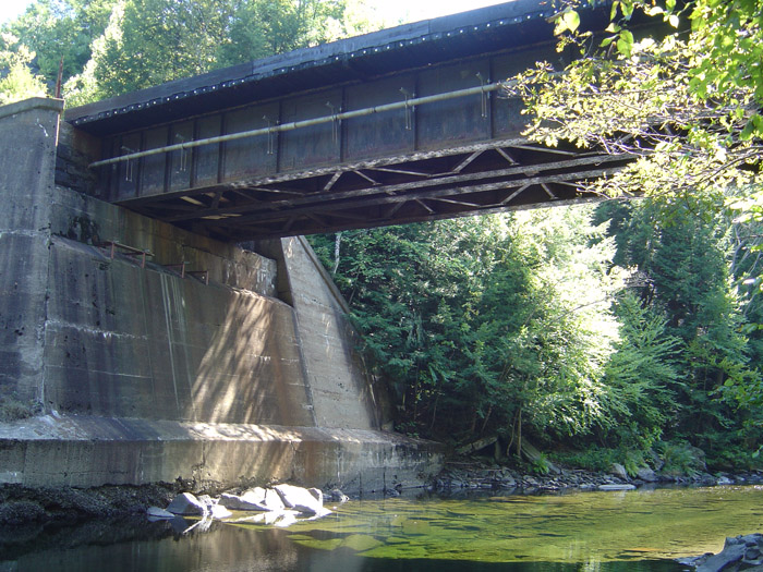 The date on this bridge was embossed in the concrete as "1928". Well, a little more modern than the arches themselves. This particular span hosts two lines. Also of note...if you are one of the types to walk next to the rail lines, don't cross bridges. Should a train come at that precise moment you have absolutely no way to get out of the way. There is no room on the sides to run.
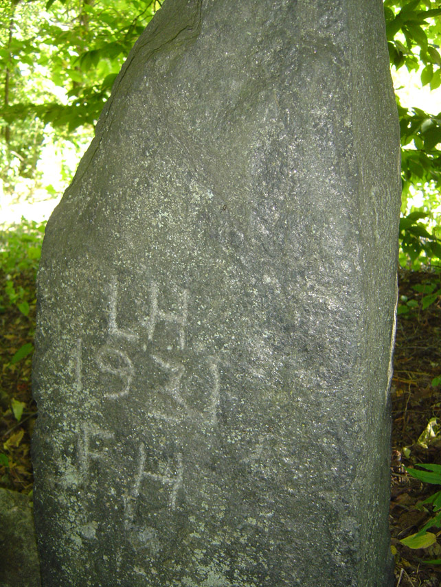
We continue on the way down the trail, following the hardpack dirt and we eventually come to a turn in the trail. I noticed something peculiar on the side of this turn in the trail. Several stones were buried upright on the righthand side, almost like this indeed was once an old road adn these stones were a 'curb' of some sorts. There were some well worn initials and a date carved into it. Somewhat hard to see in person when it is in shadow, so I used the flash on the camera to bring it out. "LH" and "FH" with the year 1931. See the photo -->
We continue on the journey. I picked up a curious squirrel escort along the way. I think maybe he was hoping that I would drop some acorns or something. He shadowed my moves about 50' back on the trail, but every time I would whip out the camera and try to take his picture he would disappear up a tree.
This got me to thinking about whether or not hunting is allowed in this area. Not that I would hunt a squirrel, but if it was hunting season I would wear orange just to be safe. I did not see any deer sign or bear sign, however, and the terrain is not terribly condusive to grouse or pheasant. The giant roaring train within eashot probably doesn't help either now that I think about it.
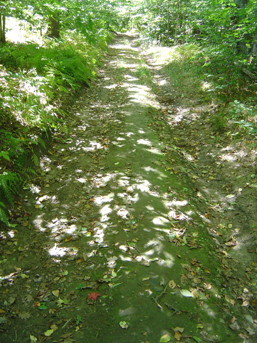
The blue blazed trail that we have been following departs from the truck road. I'm not sure why, but I stayed on the blue blazed trail even though I could plainly see the truck road below. Due to the shadows the pic of the road didn't come out. But it's a road, you're not missing much.
You will round the bend and be presented with a very sturdily built bridge. Mountain bikers will probably opt to try and cross the stream this bridge spans a little lower, as the bridge is narrow and I can imagine it would eat your handlebars if you got too close. Immediately after crossing the bridge the trail becomes narrow singletrack, with a slight uphill climb for a few minutes. It then rejoins the 'road' aka old rail bed again.
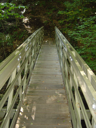
Donations to the Whister's Arches people and volunteerism is what helps support maintaining the trail and building wonderful structures like this bridge. Give a visit over to their website http://keystonearches.org/history/ and shoot 'em a donation if you can. (View their website in Internet Explorer or it will not display properly)
A few more minutes down the trail on a level walk and you will find yourself at a "T" in the road. In front of you will be another very informative kiosk. I would suggest going to your left first, as it is a two minute walk to the arch that is there. Of course I went to the right first, but that's because I was being a moron.
So for the purposes of the tour, let us say you head to the right at first. As I was walking along, I became aware of how silent it suddenly was. I coudln't hear the stream anymore, no birds, my squirrelly friend had left me in favor of something edible, and I found myself enjoying the peace.
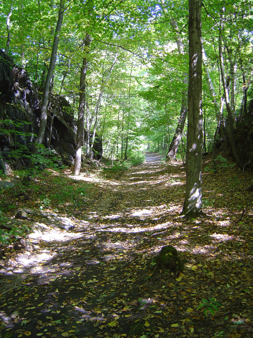
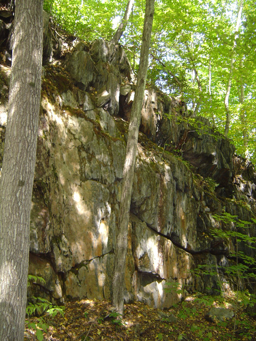
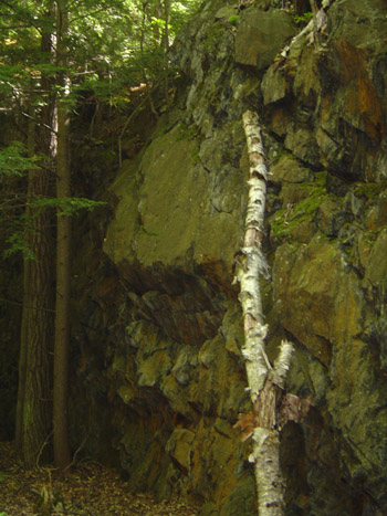
The trail, which it turns out is the old railbed (explained on the kiosk), gently turns so you can't quite see what's up ahead. Eventually, however, you will come across an awe inspiring sight. A giant 'rock cut' that was made with picks and shovels through a 70-100 foot hill of solid rock. This allowed the tracks to be laid and the train to pass through. Can you imagine removing all of that material with picks and axe? You can still see the toolmarks on the rock from where they split it.
In the right-hand picture above, if you want some perspective, my head comes up to that missing slab of bark on the bottom of the dead birch tree laying up against the rocks.
While I was standing there in the middle of this giant cut of rock, I started to feel a low rumble. The ground started to vibrate just a bit. The low rumble started to grow louder and louder. It was almost as if a ghost train was coming up these old tracks at me. It really just made the hair on my neck stand up. It's kind of eerie if you think about it. Anyway, the train was actually on the other side of the river so even though it sounded like I was about to be run over, I was perfectly safe.
Just past the rock cut you will find two concrete blocks on either side of the trail. I beleive these to be old signaling post foundations. Nearby there is some really old wire coiled up, and a tree has grown up through the middle of it. No pics of that, it wouldn't come out well due to the lighting.
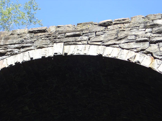
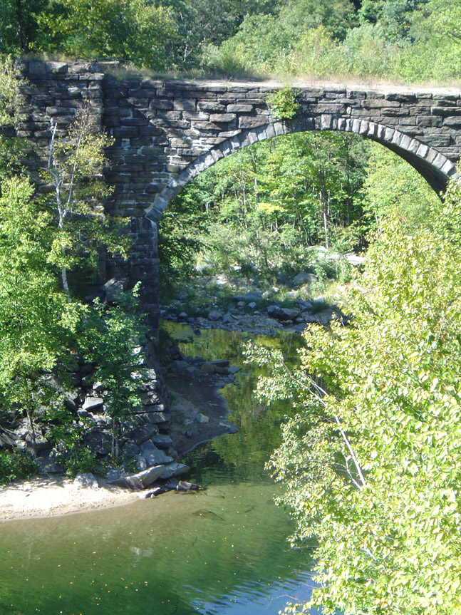
Once you see the signal posts, just keep walking for another five minutes and you are greeted with what you came here to see, one of Whistler's Arches! Words cannot express how awesome this feat of engineering is. These are known as keystone arches. There is no mortar used in their construction. The weight of the structure is what holds it in place. This 70 foot tall giant arch was laid in about 1840, the first of its kind in America. At the time this was the longest and highest railroad in the world! More history will be on the Whistler page.
Please be careful around here. There are no railings on the arches, and it is a 70 foot plunge to the bottom. Keep pets and little ones restrained. Should you want to go to the river level to investigate (trust me, you do), there are rather steep trails that follow the abutments down to the river. Be careful and don't twist an ankle.
Here are some shots of the arch. They are so big that if you get under it and make a noise, it echos quite loudly. I will let the pictures speak for themselves. Unfortunately I don't have a wide angle lens so it is tough to get the whole thing in.
 Here we have the keystone
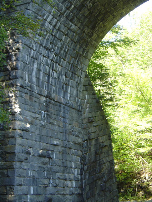
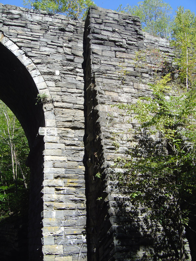
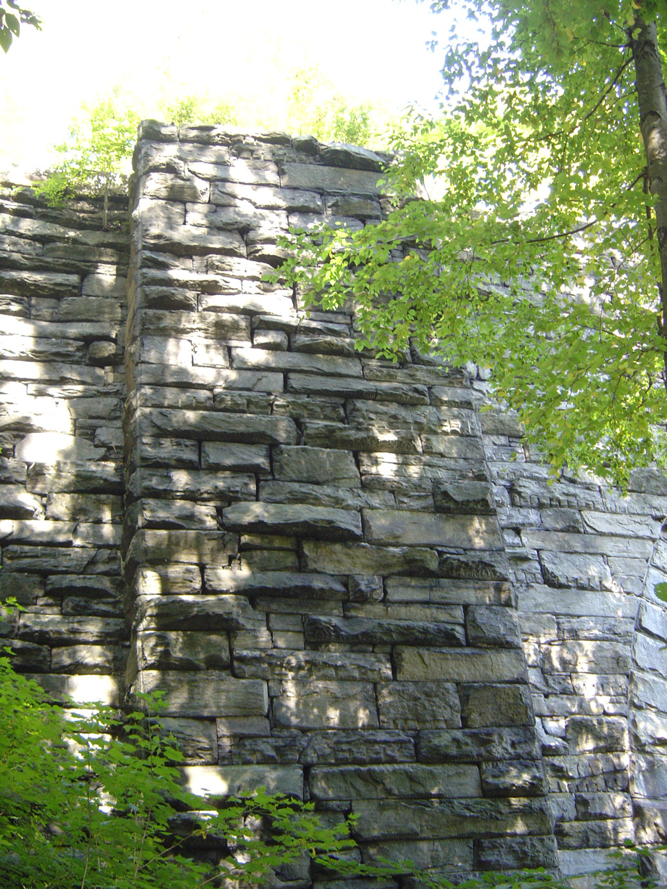
Three shots of the arches above. Doesn't it look like a castle??
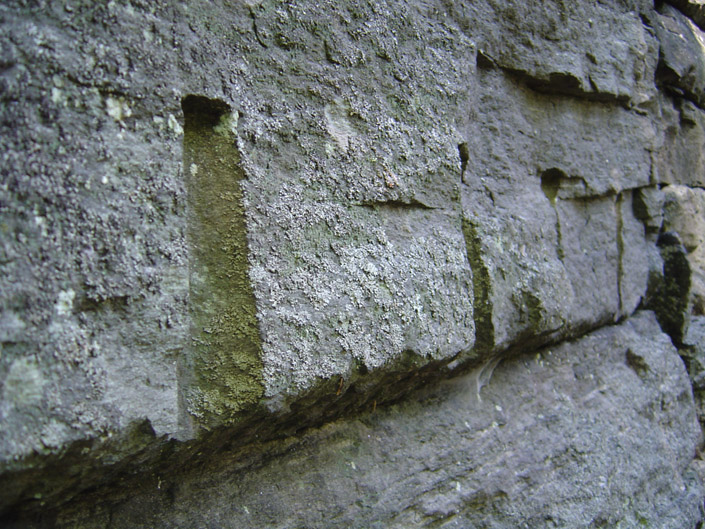
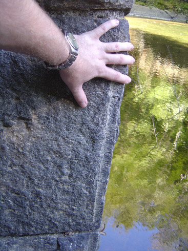
Tool marks on the rocks, and a closeup of one of the stone with my hand for scale. 4 of these stones are higher than I am tall. Also notice the motarless joints. This means there is no space...they are perfectly milled and joined. By hand!
Now if we go back to the information kiosk and continue onward (if we would have gone left instead of right the first time) we cross another arch which I got a nice shot of from far away. You kinda have to stand on the railroad tracks to get this, so be careful please!
CONTINUE TO PAGE 2
I started today's hike with the intent on finding a few geocaches in the area, "Keystone Arches" and "Whistler's Arches." I knew the area had historical signifigance as well, so I brought the camera along. This way you can come along with me as I describe the journey. Overall I spend about 3 or 4 hours there today, although the area could be done in much shorter time provided you don't stop to take in the sights. That is just not fun.
At the trailhead you will be presented with a nice information kiosk, complete with a map of the area and historical description of what went on here. There are no hand-out maps, but it is next to impossible to get lost. Nevertheless, if you have a GPS, mark your car. On the way in you can immediately tell that people do drive on this road. I am pretty sure the CSX railroad guys use this road to gain access to their rail lines for inspection. I mapped one of the roads, which doubles as the trail in parts, and it comes right out to the lines where there is a bridge.
Right before you cross an iron-grate bridge you will hear some small waterfalls to your right. There is a geocache up there, so I headed to it and snapped some pics. A nice place for a rest on the way back from your trip.
Click on any one of the images to display a full resolution picture. The original fullsize images are available upon request. (The full resolution pictures you get by clicking on these thumnails are about 25% the size of the originals!) Once you click the image your browser may resize it to fit in your browser window, click it again and it may get even bigger!
Continuing on the way I noticed I had some buzzing type visitors off to my left. They left me alone and let me take a picture of their awesomely big home. That must have been hard work for the little buggers. They have a great view of the river down below. The drop was too steep for me to risk taking a pic, sorry.
This portion of the trail is an old "highway" aka carraige/horse road that connected the Pittsfield area to the Springfield area. I beleive it was called the Pontoosuc turnpike if memory serves me correctly. I can't find any verification of that on the internet, although somewhere on one of the kiosks there is information about it.
If you pay attention as you walk the trail that meanders along the river you will notice the occasional stone wall in the woods. The sound of the trickling water is never far away. In the spring, this section of the river can be class IV whitewater. I can imagine the ghosts of the past who made these stone walls just watching those people go down the river...thinking to themselves what a strange folk we have become.
A little farther up the way and still only about 20 minutes into the hike you come across a more modern bridge then the arches you will see. It's just a short one minute 'side trail' off the main road, you can't miss it. The date on this bridge was embossed in the concrete as "1928". Well, a little more modern than the arches themselves. This particular span hosts two lines. Also of note...if you are one of the types to walk next to the rail lines, don't cross bridges. Should a train come at that precise moment you have absolutely no way to get out of the way. There is no room on the sides to run.
We continue on the way down the trail, following the hardpack dirt and we eventually come to a turn in the trail. I noticed something peculiar on the side of this turn in the trail. Several stones were buried upright on the righthand side, almost like this indeed was once an old road adn these stones were a 'curb' of some sorts. There were some well worn initials and a date carved into it. Somewhat hard to see in person when it is in shadow, so I used the flash on the camera to bring it out. "LH" and "FH" with the year 1931. See the photo -->

We continue on the journey. I picked up a curious squirrel escort along the way. I think maybe he was hoping that I would drop some acorns or something. He shadowed my moves about 50' back on the trail, but every time I would whip out the camera and try to take his picture he would disappear up a tree.
This got me to thinking about whether or not hunting is allowed in this area. Not that I would hunt a squirrel, but if it was hunting season I would wear orange just to be safe. I did not see any deer sign or bear sign, however, and the terrain is not terribly condusive to grouse or pheasant. The giant roaring train within eashot probably doesn't help either now that I think about it.
The blue blazed trail that we have been following departs from the truck road. I'm not sure why, but I stayed on the blue blazed trail even though I could plainly see the truck road below. Due to the shadows the pic of the road didn't come out. But it's a road, you're not missing much.
You will round the bend and be presented with a very sturdily built bridge. Mountain bikers will probably opt to try and cross the stream this bridge spans a little lower, as the bridge is narrow and I can imagine it would eat your handlebars if you got too close. Immediately after crossing the bridge the trail becomes narrow singletrack, with a slight uphill climb for a few minutes. It then rejoins the 'road' aka old rail bed again.
Donations to the Whister's Arches people and volunteerism is what helps support maintaining the trail and building wonderful structures like this bridge. Give a visit over to their website http://keystonearches.org/history/ and shoot 'em a donation if you can. (View their website in Internet Explorer or it will not display properly)
A few more minutes down the trail on a level walk and you will find yourself at a "T" in the road. In front of you will be another very informative kiosk. I would suggest going to your left first, as it is a two minute walk to the arch that is there. Of course I went to the right first, but that's because I was being a moron.
So for the purposes of the tour, let us say you head to the right at first. As I was walking along, I became aware of how silent it suddenly was. I coudln't hear the stream anymore, no birds, my squirrelly friend had left me in favor of something edible, and I found myself enjoying the peace.
The trail, which it turns out is the old railbed (explained on the kiosk), gently turns so you can't quite see what's up ahead. Eventually, however, you will come across an awe inspiring sight. A giant 'rock cut' that was made with picks and shovels through a 70-100 foot hill of solid rock. This allowed the tracks to be laid and the train to pass through. Can you imagine removing all of that material with picks and axe? You can still see the toolmarks on the rock from where they split it.
In the right-hand picture above, if you want some perspective, my head comes up to that missing slab of bark on the bottom of the dead birch tree laying up against the rocks.
While I was standing there in the middle of this giant cut of rock, I started to feel a low rumble. The ground started to vibrate just a bit. The low rumble started to grow louder and louder. It was almost as if a ghost train was coming up these old tracks at me. It really just made the hair on my neck stand up. It's kind of eerie if you think about it. Anyway, the train was actually on the other side of the river so even though it sounded like I was about to be run over, I was perfectly safe.
Just past the rock cut you will find two concrete blocks on either side of the trail. I beleive these to be old signaling post foundations. Nearby there is some really old wire coiled up, and a tree has grown up through the middle of it. No pics of that, it wouldn't come out well due to the lighting.
Once you see the signal posts, just keep walking for another five minutes and you are greeted with what you came here to see, one of Whistler's Arches! Words cannot express how awesome this feat of engineering is. These are known as keystone arches. There is no mortar used in their construction. The weight of the structure is what holds it in place. This 70 foot tall giant arch was laid in about 1840, the first of its kind in America. At the time this was the longest and highest railroad in the world! More history will be on the Whistler page.
Please be careful around here. There are no railings on the arches, and it is a 70 foot plunge to the bottom. Keep pets and little ones restrained. Should you want to go to the river level to investigate (trust me, you do), there are rather steep trails that follow the abutments down to the river. Be careful and don't twist an ankle.
Here are some shots of the arch. They are so big that if you get under it and make a noise, it echos quite loudly. I will let the pictures speak for themselves. Unfortunately I don't have a wide angle lens so it is tough to get the whole thing in.
Three shots of the arches above. Doesn't it look like a castle??
Tool marks on the rocks, and a closeup of one of the stone with my hand for scale. 4 of these stones are higher than I am tall. Also notice the motarless joints. This means there is no space...they are perfectly milled and joined. By hand!
Now if we go back to the information kiosk and continue onward (if we would have gone left instead of right the first time) we cross another arch which I got a nice shot of from far away. You kinda have to stand on the railroad tracks to get this, so be careful please!
CONTINUE TO PAGE 2